What is Earth Orientation?
The term "Earth orientation" refers to the direction in space of axes which have been defined on the Earth. It is usually measured using five quantities: two angles which identify the direction of the Earth's rotation axis within the Earth, an angle describing the rotational motion of the Earth, and two angles which characterize the direction of the Earth's rotation axis in space. With these angles, the orientation of the Earth in space is fully described. The Rapid Service/Prediction Center of the International Earth Rotation and Reference Systems Service (IERS), located at the U.S. Naval Observatory (USNO), monitors the Earth's orientation and disseminates this information to many organizations on a continuous basis.
POLAR MOTION
The angles which characterize the direction of the rotational pole within the Earth are called the polar coordinates, x and y. Variation in these coordinates is called polar motion. The polar coordinates describe the position of the Earth's instantaneous pole of rotation in a reference frame which is defined by the adopted locations of terrestrial observatories. The coordinate x is measured along the 0° (Greenwich) meridian while the coordinate y is measured along the 90° W meridian. These two coordinates determine the directions on a plane onto which the polar motion is projected.
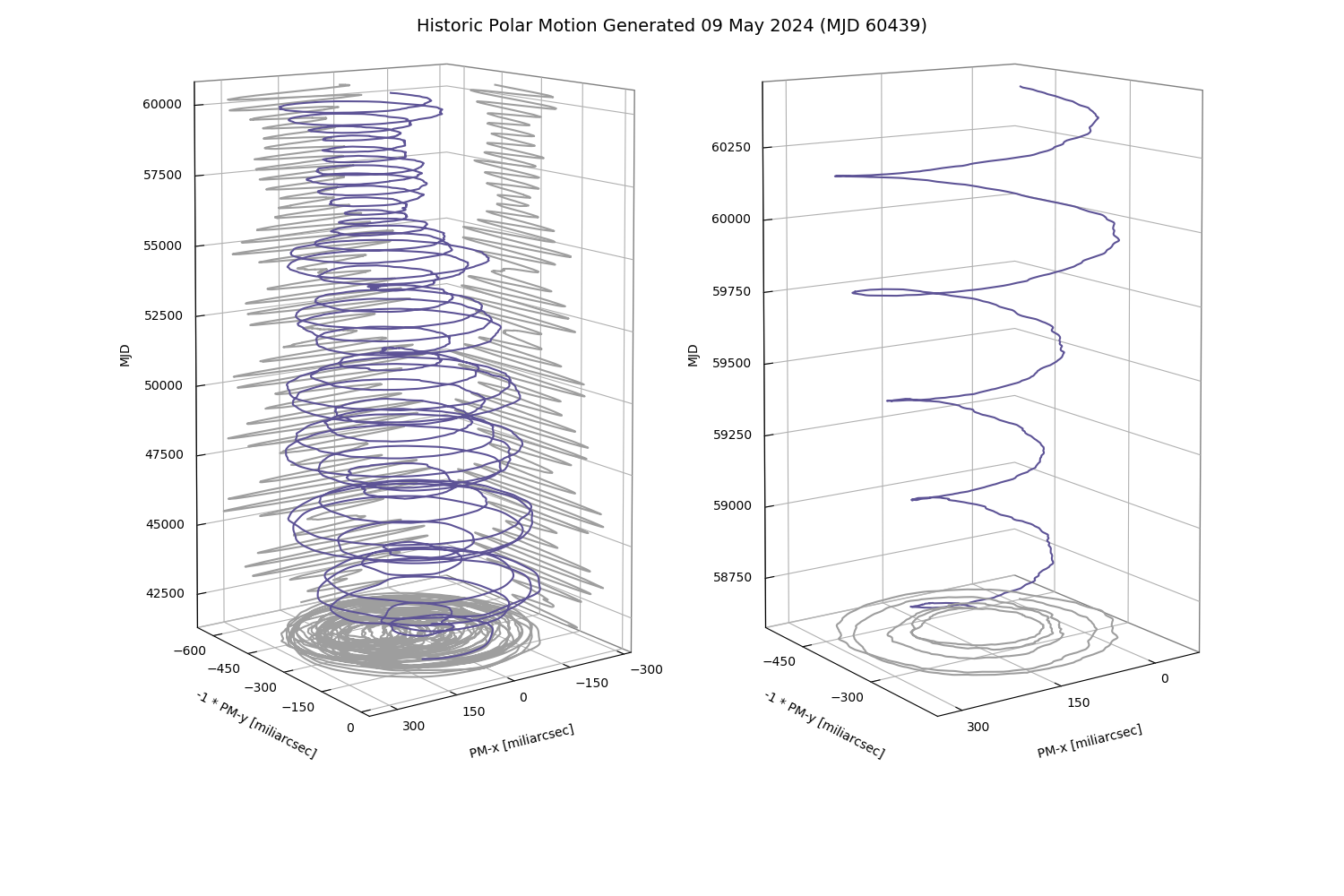
In addition to largely unpredictable motions, polar motion consists of a secular motion and two principally periodic motions; an annual elliptical component and a Chandler circular component with a period of about 435 days. These two periodic motions describe most of the spiral motion of the pole as seen from the Earth (Figure 1 below).

EARTH ROTATION (UT1-UTC)
The Earth's angular rotation coordinate measures the angle through which the Earth has turned in a given period of time. This angle expressed as the difference between a time scale measured by the rotation of the Earth, UT1, and a uniform time scale, UTC, refers to the angular difference between the direction of the 0° meridian on the Earth and the direction to a conventional direction point defined in space astronomically.
Historically some form of time based on the rotation of the Earth has always been the basis for civil time, the definition and the measurement procedures depending on available technology and precision requirements. In modern practice, UT1 is defined using a fiducial direction defined mathematically in the celestial reference system. This direction is referred to as the Conventional Intermediate Pole.
UTC, standing for Coordinated Universal Time, designates the atomic time scale which approximates the rotational time of the Earth. From the time of its inception, its rate and/or epoch have been adjusted to keep it near UT1. The current practice is to adjust UTC in epoch by integral seconds (leap seconds) to keep the difference between UT1 and UTC less than 0.9 seconds. UTC as defined by the International Radio Consultative Committee (CCIR) Recommendation 460-4, differs from TAI (Temps Atomique International) by an integral number of seconds. TAI is an atomic time scale determined by the Bureau International des Poids et Mesures (BIPM). Its unit is exactly one Système Internationale (SI) second at mean sea level.
LENGTH OF DAY
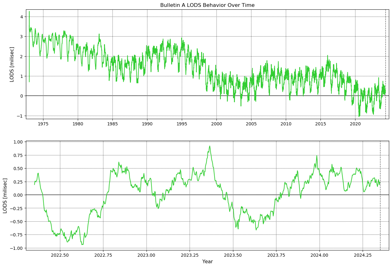
Analyses of astronomical observations reveal different types of variations in the speed of the Earth's rotation. The ancient observational data of solar eclipses form the basis for estimates of the secular deceleration in the speed of rotation. The more recent information, having been obtained with higher accuracy and more regularly, has shown the changes in the acceleration causing irregular variations in the length of the day (LOD). These data have also been used to detect the periodic variations in the length of the day. Figure 2 (below) shows the difference between the rotationally determined length of day (corrected for the effects of known tidal variations, LODS) and 24 hours of UTC time, otherwise known as the excess length of day (in milliseconds).

OFFSETS OF THE CELESTIAL POLE
The gravitational attraction of the Sun and Moon on the non-spherical Earth causes the rotational axis of the Earth to precess in space similar to the action of a top. In addition to this precessional motion, the axis undergoes a small "nodding" motion called nutation. Both of these motions can be described theoretically to a high degree of accuracy using angular coordinates X and Y in a situation analogous to that of polar motion. However, in this case the angular coordinates describe the direction of the Earth’s pole in a celestial reference system. This mathematical description depends on assumed values of physical constants describing the shape and internal structure of the Earth. Observations indicate that small residual corrections, dX and dY, are required to the currently adopted International Astronomical Union (IAU) model.
WHAT CAUSES VARIATIONS IN THE EARTH'S ORIENTATION?
Various factors which cause the orientation of the Earth to change with time. Polar motion is caused, in part, by large scale movements of water and changes in the atmospheric angular momentum. Any significant change in the distribution of the Earth’s mass will affect the polar motion. This includes large scale movements of water and changes in the atmospheric angular momentum. For example, the yearly melting of snow and ice in Northern Hemisphere Spring contributes to the annual term of polar motion.
The secular variation of the rotational speed is due chiefly to tidal friction. The Moon raises tides in the ocean diminishing the speed of rotation. This causes a slowing of the Earth's rotational speed, resulting in a lengthening of the day by about 0.0015 to 0.0020 seconds per day per century. Irregular changes are correlated with physical processes occurring on or within the Earth. These cause the length of the day to vary by as much as 0.001 to 0.002 seconds. Irregular changes consist of "decade fluctuations" with characteristic periods of five to fifteen years as well as variations which occur at shorter time scales. The decade fluctuations are related apparently to processes occurring deep within the Earth. The higher frequency variations with periods less than two years are now known to be related largely to the changes in the total angular momentum of the atmosphere.
Periodic variations are associated with periodically repeatable physical processes affecting the Earth. Tides raised in the solid Earth by the Moon and the Sun produce variations in the length of the day with a total amplitude on the order of 0.001 seconds and with individual periods of 18.6 years, 1 year, 1/2 year, 27.55 days, 13.66 days and others. A standard model, including 62 periodic components, can be employed to correct the observations for solid Earth tidal effects.
The rotational speed of the Earth remains essentially unpredictable in nature due to incompletely understood variations. Because of this, astronomical observations continue to be made regularly with increasing accuracy, and the resulting data are the subject of continuing research in the field.
HOW DO WE OBSERVE EARTH ORIENTATION?
To determine Earth orientation, observations must be made from the Earth of objects located in space. Objects that are used include stars, artificial satellites, the Moon, and distant radio sources called quasars. These provide useful reference directions with which to measure the Earth's orientation. Stars had been observed photographically for decades to determine the motion of the pole and the rotation of the Earth. Recently, more accurate methods have been devised including the use of lasers and radio telescopes. Laser bursts can be reflected off of artificial satellites or the Moon. This provides information on exactly where the object is at a particular time which, in turn, can be used to determine the Earth's orientation in space.
Radio telescopes are used in a technique called Very Long Baseline Interferometry (VLBI). By having several radio telescopes observing the same quasar at the same time, and recording the information that is seen at each telescope, the Earth's orientation can be determined. The recorded information is then processed further before the final results can be determined. The reduction procedure involves the use of a highly specialized computer called a correlator. Once the data from a VLBI observing session has been correlated, it can be processed further to produce information on Earth orientation and other useful quantities. USNO participates in correlating and analyzing observations from international and domestic VLBI networks for the purpose of measuring Earth orientation.
Astronomical observations are made routinely by a number of observatories located around the world for this purpose. The IERS is the international organization responsible for coordinating observations of polar motion and nutation as well as rotation angle. This organization consists of product centers that provide specific services to users, such as rapid service/predictions of Earth orientation, data related to the motions of geophysical fluids (e.g., atmosphere and oceans), and the celestial and terrestrial reference frames. Observations are contributed to the IERS by individual observing techniques, which in turn receive results from numerous observatories, laboratories, and analysis centers around the world. The IERS Rapid Service/Prediction Center then combines these data into a series of polar motion x, polar motion y, UT1-UTC, and celestial pole offsets. This information is recomputed at least daily and disseminated on our website, the IERS website, and CDDIS.
WHO USES EARTH ORIENTATION INFORMATION?
Anyone who must relate changing aspects of reference systems on the Earth to a system in space may require information on the Earth's orientation. Users include navigators, geodesists, and those involved in timekeeping. Precise positions of satellites located hundreds to tens of thousands of kilometers away in space must take into account the Earth's variable rotation. Without this information, the positions of the satellites cannot be accurately related to points on the Earth's surface, which is necessary for many space-based applications. The universal use of artificial satellites for world-wide navigation and communication makes this an area of important concern.
Suggested Reading
- Lambeck, K., 1980, The Earth's Variable Rotation: Geophysical Causes and Consequences, Cambridge University Press, London.
- Munk W. H. and MacDonald, G. J. F., 1960, The Rotation of the Earth, Cambridge University Press, London.
- McCarthy, D. and Seidelmann, P., 2018, Time: From Earth Rotation to Atomic Physics. In Time: From Earth Rotation to Atomic Physics (pp. I-Ii). Cambridge: Cambridge University Press